Friday, August 04, 2006
The Luckiest People in the World
Pinch me. I hope I never lose the wonder of living my dream. My dream was/is to travel around to beautiful places yet have my home and my work with me wherever I go. Luckily, that's Jim's dream too! And we are living it.
Here's a satellite photo from google maps of where we are right now:
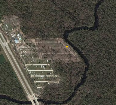
You can always see this map of where we are by clicking on the link in the right column that says, "Map of where we are now". That takes you to the DatastormUsers.com map which I update whenever we move (unless I forget). Scroll down to the bottom to where you see our names and you should notice a place where you can control the 'zoom'. Click on the + all the way to the right to zoom in to the closest view, then click on the button at the top for "Google Hybrid" to see the satellite imagery. Pretty cool.
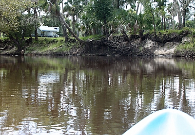
Yesterday was my perfect day. We got up and took Odie for a walk on the nature trail along the river and thru the woods. Came back to our motorhome parked on the banks of the river with no one else around. We had coffee and breakfast and worked at our computers for a few hours. Then, Debbie, the manager here drove us and our kayaks up the road a ways to a boat launch. We paddled/floated down river for a couple hours seeing alligators, turtles, great blue herons and ospreys and other hawks.
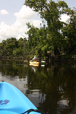
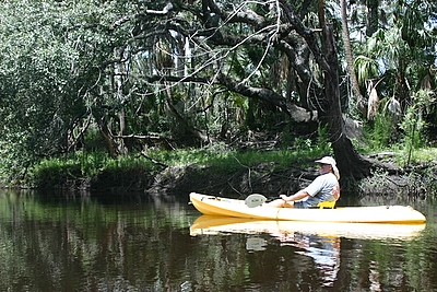
hmmm ... doncha wonder why they call it the "Peace" river? The only person we saw was a fish and wildlife officer in an airboat - he was gone in a flash.
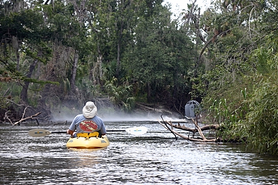
After an hour or two of this meditative paddle, we rounded a bend and saw ...
Home!
Then we took a drive to the only local tourist attraction ... Solomons Castle. Unfortunately it was closed for the summer - but it was a nice drive anyway.
We came home, put in a few more hours on the computer, had dinner, and topped it all off with a soak in the hot tub.
On second thought ... don't pinch me. I don't want to wake up!
Here's a satellite photo from google maps of where we are right now:
You can always see this map of where we are by clicking on the link in the right column that says, "Map of where we are now". That takes you to the DatastormUsers.com map which I update whenever we move (unless I forget). Scroll down to the bottom to where you see our names and you should notice a place where you can control the 'zoom'. Click on the + all the way to the right to zoom in to the closest view, then click on the button at the top for "Google Hybrid" to see the satellite imagery. Pretty cool.
Yesterday was my perfect day. We got up and took Odie for a walk on the nature trail along the river and thru the woods. Came back to our motorhome parked on the banks of the river with no one else around. We had coffee and breakfast and worked at our computers for a few hours. Then, Debbie, the manager here drove us and our kayaks up the road a ways to a boat launch. We paddled/floated down river for a couple hours seeing alligators, turtles, great blue herons and ospreys and other hawks.
hmmm ... doncha wonder why they call it the "Peace" river? The only person we saw was a fish and wildlife officer in an airboat - he was gone in a flash.
After an hour or two of this meditative paddle, we rounded a bend and saw ...
Home!
Then we took a drive to the only local tourist attraction ... Solomons Castle. Unfortunately it was closed for the summer - but it was a nice drive anyway.
We came home, put in a few more hours on the computer, had dinner, and topped it all off with a soak in the hot tub.
On second thought ... don't pinch me. I don't want to wake up!
posted by Chris at 8/04/2006 08:43:00 AM
0 Comments:
links
2 computer geeks and one perfect poodle, live and travel in their RV making a living with computer skills. Computer Education for RVers, Internet Satellite Installations, Wi-Fi help, Website design.
Previous Posts
- Google Earth
- Blog Migration Successful!
- Blogger migration
- Water in the River
- Christmas Day
- It's a Wonderful Life
- Sittin' on the Bench of the Bank
- The Park is filling up
- Solomons Castle
- Visitors
Archive
My links
- Blog Index
- Site Feed
- Map of where we are now
- "Geeks on Tour" Our Business Website
- Our Web-based Photo Albums
- Mom's Blog
- Other RVers
- Diane and Andy's Blog
- Tioga and George
- Brightwing RV
- Lynne and John
- Cliff and Marie
- Hitch Itch: RV Travel Adventures and Journals
- Gypsy John
- Anne and Norm (fellow divers now discovering RVing!)
![]()